New York Geology: Explore a Billion Years of Earth's History
by Betsy McCully
Updated August 2026
“Plate tectonic configuration during Late Pre-cambrian through Early Paleozoic time for New York City,” USGS [Public Domain]
Manhattan's Ancient Bedrock
Imagine a skyline of sky-scraping mountain peaks! Manhattan’s bedrock reveals continents colliding together and rifting apart over a period of a billion years. The story of New York geology takes you into deep time.
The bedrock that anchors Manhattan’s skyscrapers was formed between 450 million and over a billion years ago. Three strata underlie Manhattan and shape its topography: Fordham Gneiss, Manhattan Schist, and Inwood Marble.
How was Manhattan's bedrock formed?
The most ancient of the three strata is Fordham Gneiss. Gneiss is a metamorphic rock formed when ancient granite bedrock was subjected to intense heat over a billion years ago during a mountain-building episode known as the Grenville Orogeny. Half a billion years later, during the Taconic Orogeny, the granite bedrock was overthrust and interlayered with the schist and marble strata, forming the Manhattan Prong. Fordham Gneiss forms the Riverdale and Grand Concourse ridges in the Bronx.
Manhattan Schist is a metamorphic rock formed around 450 million years ago when continents collided, pushing up mountains high into the sky. This mountain-building episode is known as the Taconic Orogeny. Schist forms the island’s spine from the Henry Hudson Bridge on its north end to the Battery on its southern tip; it dips abruptly several hundred feet below ground at Washington Square, and makes a gradual ascent beginning at Chambers Street. These dips and rises account for the gap between “Midtown” and “Downtown” in the Manhattan skyline, since tall buildings had to be anchored on solid bedrock and not on the glacial till that fills the valleys.
Inwood Marble is metamorphosed limestone formed around the same time as the Manhattan Schist. Ranging from 150 to 500 feet thick, the marble strata form the bedrock beneath the Harlem River, East River and adjacent regions; the marble strata erupt above ground as a ridge that extends from Dyckman Street on Manhattan’s Upper West Side northward to Marble Hill at Manhattan’s northern tip.
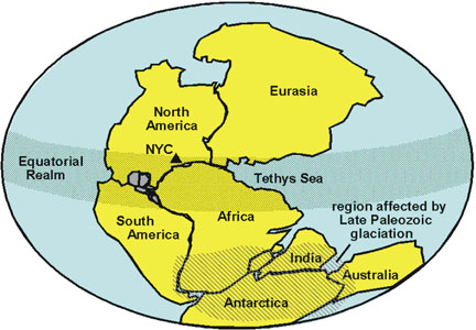
By around 300 million years ago, earth’s continents fused into a supercontinent called Pangaea. Pangaea began rifting apart around 200 million years ago, forming the New Jersey Palisades.
“Geologic Map of Northern Manhattan and the Bronx (modified after Schuberth, 1967),” USGS [Public Domain]
The supercontinent Pangaea in Late Paleozoic time (about 300 mya), USGS [Public Domain]
Credit: USGS, “Simplified cross-section of northern Manhattan and the Bronx along I-95”
New Jersey Palisades
The geological formation known as the Palisades along the Hudson River offers a dramatic window into the rifting of Pangaea, when continents broke apart. Lava erupted through rift valleys and intruded into sandstone layers. When the lava cooled, it formed beds of dolerite enclosed in layers of sandstone. As the rift valley subsided, the sandstone and dolerite layers were tilted and exposed; over time the red sandstone envelope eroded away, leaving the dramatic basalt cliffs of the Palisades.
Credit: USGS, Manhattan Schist exposed at The Lake in Central Park
Where to See the Rocks
Manhattan
Central Park and Inwood Hill Park are two of the best places to see outcrops of Manhattan Schist.
Central Park is, of course, in the center of Manhattan. Download a map of the park from the Central Park Conservancy (centralparknyc.org), and if you’re more scientifically inclined, take a look at the geological tour maps of this park and others on Manhattan provided by Charles and Mickey Merguerian of Hofstra University on their wonderful geology website, Duke Geological Labs. Two of the most famous of the outcrops are Umpire Rock, aptly named because it overlooks the Heckscher Ballfields in the southwest area of the park; and The Platform in the park’s southeast side (east of the Dene, north of the Playground around 68th Street). You can see other exposures of schist just west of the Carousel and around The Pond in the park’s southeast corner. On the park’s west side around 72d Street, The Lake offers good exposures. Take a close look at the outcrop surfaces for the scratches, striations, and grooves left by the last glacier. Besides schist outcrops you’ll notice many glacial erratics, rocks transported from elsewhere by glaciers. See my Ice Age page to learn more about this last geological event in the NYC region.
Inwood Hill Park is on the northern tip of Manhattan (bordered by Dyckman and Payson streets on its south and east sides, the Hudson River on its west side, and the Harlem Ship Canal on its north). Here you can observe the three bedrock strata in the landforms: Manhattan Schist underlies the ridge of Inwood Hill; Inwood Marble underlies the Harlem River; and Granite Gneiss surfaces as the Riverdale Ridge across the Harlem Ship Canal. The Manhattan Schist outcrops in Inwood Hill Park reveal glacial striations made by the scraping of a glacier over the rock tens of thousands of years ago. At the westernmost end of the park, where the trail climbs the ridge to an overlook above the Hudson, you can see the vertical blocky cliffs of the New Jersey Palisades rising over the river. So you are in effect looking across a huge span of time: you are standing on a metamorphic rock formation dating back 450 million years to the collision of continents and looking at a sedimentary and igneous rock formation dating back to the breaking up of Pangaea 200 million years ago!
View of the Palisades looking across the Hudson River from the Bronx, by Betsy McCully
Inwood Marble outcrop in Isham park, Manhattan, by Betsy McCully
Across the street from Inwood Hill Park is Isham Park, the pocket park on Isham Street at the corner of Seaman Avenue. Here you can see beautiful outcrops of Inwood Marble.
Schist outcrop, Pelham Bay Park, by Betsy McCully
The Bronx
For an even greater time span than the overlook at Inwood Hill Park, you can visit Wave Hill, a lovely garden and preserve in the Riverdale section of the Bronx, overlooking the Hudson River. At their overlook, you can look across the river to the 200-million-year-old Palisades while standing on a ridge of billion-year-old Fordham Gneiss!
Pelham Bay Park has beautiful exposures of schist on North and South Twin Islands, Orchard Beach. (These schist outcrops, known as the Hartland Formation, are distinct from Manhattan Schist. Manhattan Schist was formed in a shallow water environment whereas Hartland Schist was metamorphosed from shale formed in a deep oceanic environment.)
New York Geology Reading List
Graff, M. M. and Thomas Hanley. Rock Trails in Central Park (The Greensward Foundation, 1976)
McCully, Betsy. City at the Water’s Edge: A Natural History of New York (Rutgers University Press, 2007)
McCully, Betsy. At the Glacier’s Edge: A Natural History of Long Island from the Narrows to Montauk Point (Rutgers University Press, 2024)
Roberts, David C. Geology of Eastern North America, Peterson Field Guides (Houghton Mifflin, 1996)
Van Diver, Bradford. Roadside Geology of New York (Mountain Press Publishing, 2003)